


9—When Do You Stop
How much flooding can the levees withstand?

When the U.S. Army Corps of Engineers began looking at options for Tulsa’s failing levee system in 2018, Mayor G.T. Bynum and multiple state and county officials petitioned the Corps to raise the height of the levees.
Among them, Reps. Kevin Hern and Markwayne Mullin (now a U.S. Senator), Sen. Jim Inhofe, and two county commissioners submitted variations of the request, calling it “imperative” to increase the levee capacity to a 500-year flood or higher, up to the Probable Maximum Flood.
The Corps reported that raising the height of the levees would increase flood depths nearby.
This effect, called risk transfer, was most pronounced in two very different areas: the Town and Country subdivision west of Tulsa,1 and lower Maple Ridge, home to the “World Class Gathering Place,” as officials sometimes call it.
When the Corps simulated a so-called 500-year flood, then estimated at 490,000 cubic feet per second (cfs),2 with levees raised to the same standard, flood depths increased by 2 to 5 feet in both locations.
At Town and Country, a modest suburban neighborhood, the Corps identified 75 to 100 affected homes.3 Among the high-value properties of Maple Ridge, the number looks to be closer to 50.
The Corps elected not to increase the levee capacity under the rationale that this transfer of risk was “not trivial” to residential and public use areas with “significant levels of financial investment.”4
When you consider the particulars5 of the Arkansas River at 490,000 cfs—an epic flood unseen in Tulsa—the Corps’ logic raises a number of questions. Four hundred and ninety thousand cfs would render the levee system obsolete at its current height.
Town and Country would be fully inundated long before flows reached this point, with or without taller levees. As Levee Commissioner Todd Kilpatrick put it, higher water in the neighborhood becomes “a moot point” in such an event.

Without a valid argument at Town and Country, the Corps’ decision not to increase the levee capacity appears to depend on an increased risk to a public park and fewer than a hundred homes in Maple Ridge.
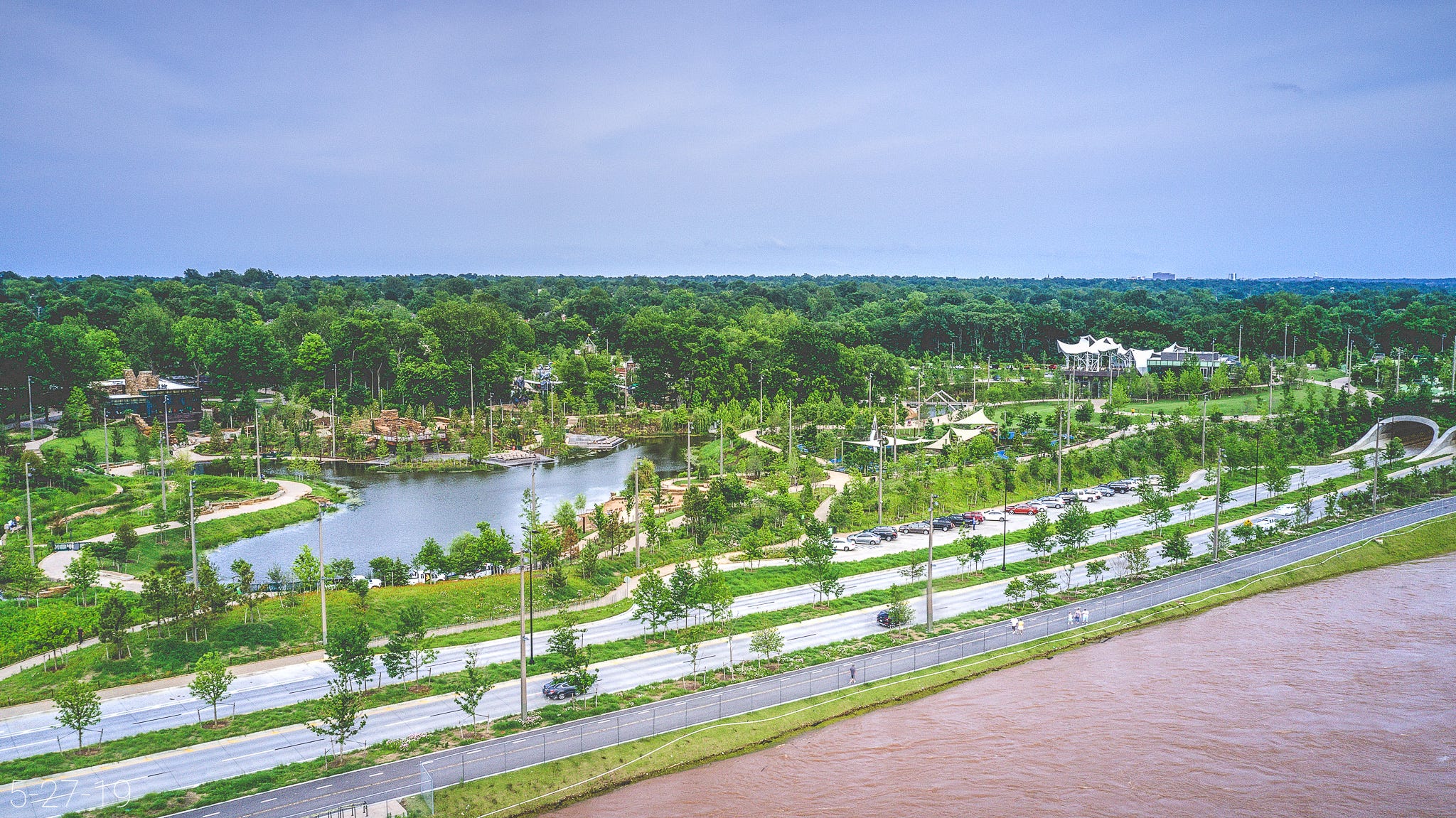
In this light, the George Kaiser Family Foundation’s $465 million Gathering Place—a gift voters did not have the chance to decline—looks like a terrible choice for Tulsa.
I shared this observation with David Williams, the hydraulic engineer for the levee study, in a phone interview May 11, 2022.
Before I continue: Williams’ diligence and responsiveness over more than two years of correspondence have been indispensable to my understanding of the levees, the status of Keystone Dam, and Tulsa’s Arkansas River flood probabilities.
Williams pushed back on the notion that Maple Ridge and Gathering Place were the reason the Corps opted not to raise the height of the levees.
“That was a reason,” Williams said. “But it’s not just Maple Ridge.”
“I want to be sure I am understanding exactly what was meant,” I said.
“I understand your interpretation of that,” Williams said. “And, I mean, the discussion can’t occur without discussing impacts to the Gathering Place because it is a very significant investment along the river.
“But, this study and the rehabilitation of the levee was based solely off of life safety concerns. … It just wasn’t feasible, from the perspective of the study, to consider raising those levees. There was no justification for doing so.”
“There was no justification for doing so?” I asked.
“Well, okay,” Williams said. “How tall do you build the levee? Do you double it in height, do you triple it? … The question is, well when do you stop? If you’re going to increase the height of a levee, when do you stop? Are you gonna build it a mile tall? I mean, that’s the practical question.”
“The study really made it appear that the Gathering Place is the driving factor,” I said.
“And it’s not,” Williams said. “It is a factor. It certainly is a factor.”
“And how big of a factor would you say it is?” I asked. “Because the way [the study] described it, it really focused on Gathering Place and low-lying areas of Maple Ridge. And I feel like, as a reader of [the levee study], we have to be able to take that for what it is.”
“Right,” Williams said.
“Is the study inaccurate then?” I asked.
“No, the study is not inaccurate,” Williams said. “But in my opinion, and when I was part of the study, the Gathering Place was not dictating what we did or didn’t recommend. It was the concern for life safety.”
Williams said there was “real concern of increased flood risk” to downstream neighborhoods. He said the transfer of risk extended south of 41st Street, tapering to less than 6 inches of increased depth around I-44.
However, the levee report specified that the effects were less pronounced south of the pedestrian bridge, which connects to Gathering Place around East 29th Street.
Williams said the increased depth south of the pedestrian bridge was closer to 2 feet but "could be as much as 5 feet" in some places.
“In retrospect, it should also say areas along Riverside Drive, including near 21st Street, south into the Maple Ridge neighborhood, and continuing south into the Travis Park neighborhood and Brookside,” Williams said. “That’s really—that was the intent of that discussion on the unacceptable transfer of risk in that study.”
What about the risk to thousands of households behind the levees?
Chemical and environmental engineer Fred Storer said offsite consequence data viewed in 2021 showed nearly 2.3 million pounds of chemical hazards at two sites behind Levee A: tens of thousands of pounds of chlorine and sulfur dioxide at Brenntag Southwest, and more than a million pounds of ethylene oxide at Baker Petrolite Corporation, which was bought by an India-based chemical company in 2020.6
I have not obtained the latest inventories for the site, but the former owner estimated that a worst-case release of formaldehyde7 would create a 20-mile radius of toxic exposure.
“If they have a leak, then it’s going to be a chemical cloud that blows downwind and harms people,” Storer said. “If you were within a mile of the tank and it had a big leak, you might die.”
The Corps ruled out a residential buyout behind Levees A and B (more than 2,000 homes) but estimated the cost at $200 million to $400 million (pre-pandemic).
(Tulsa County’s $14.7 million buyout program for residents affected by 2019 flooding is ongoing.)8
County Commissioner Karen Keith, who is running for Tulsa mayor, said the region “desperately” needs housing at the price point behind the levees.
“For us to wipe all those out would be absolutely—I don’t know where we’d put people,” Keith said in an August 2022 phone interview.
I noted the area’s unsuitability for anyone to live due to the flood risk.
“But that’s the reason we’re fixing these levees,” Keith replied.
Many of Keith’s constituents live near the river or behind the levees. Are they aware that Levee C is not included in the planned repairs?
“You know, I’m not sure about that,” Keith said, matter-of-factly.
“That concerns me,” I replied. “The impression you all have sent is not what is actually happening.”
“Okay,” Keith said. “Yeah. We can, we can—uh, maybe get that message out. I’ll have Todd [Kilpatrick] work on what needs to be said with the Corps, and we can, uh—bolster that.”
Ten months later, Kilpatrick said Keith had not contacted him about this issue.
The Corps did not consider a residential buyout behind Levee C.
Keith’s 2024 mayoral campaign commercial about the levee system emphasizes her role in securing funds “to rebuild and strengthen the Arkansas River levees so we can prevent future catastrophic flooding, save lives, and safeguard economic investment.”
HF Sinclair West refinery at I-244 and the Arkansas River. Courtesy of Fieldguide Media
In a May 18, 2022 phone interview, I asked Gaylon Pinc, senior environmental program manager for PMG9 and consultant to the levee district, about the outcome of the levee study.
Pinc (pronounced Pence) is also the project manager for the Zink Dam development.10
“You can’t protect your upstream area to the detriment of your downstream area,” Pinc said, referring to the transfer of risk.
“Well, but that’s not just cut and dried,” I said. “You have to make a judgment call about the transfer of risk, right? It’s not, We can never transfer any risk. You have to assess—”
“Yeah, that’s a big word,” Pinc said.
“What?” I asked.
“So, in this case, the transfer of risk was so great that it was not a feasible alternative,” Pinc said. “I’m just gonna leave it at that.”
“Did you agree with that finding?” I asked.
“Oh, absolutely,” Pinc said. “Yes. I do.”
“Did you agree with the determination not to repair Levee C?” I asked.
Pinc paused for perhaps the longest period in our nearly 2-hour interview. He introduced a few different lines of reasoning, cutting himself off several times before taking an inhale.
“Their—the evaluation was pretty clear,” Pinc said. “And considering their—the metrics for their economic—it was—it was shallow flooding, so they didn’t have a lot of—”
“Okay,” Pinc said. “So, personally, I would have liked to have seen something done to Levee C. And we are; we’re going to repair, replace and upgrade the two pump stations, 6 and 7, that serve Levee C.11 But nothing else. So, um, Levee C didn’t have enough flooding damage by their metrics to warrant it, so there’s really no way to argue.”
“The Corps noted that they did not assess the risk of release of the chemical hazards that are in the floodplain behind the levee,” I said. “Is that concerning to you?”
“Well, I think there are probably some issues there that were skirted over like that, that they couldn’t quantify,” Pinc said. “It’s not an arguable point. We’re not gonna throw a tantrum and make them include Levee C.”
“Have you advised your clients with the Zink Dam, this recreational attraction, that there’s a strong potential of a chemical accident if a flood occurs?” I asked.
“Those who are in the decision-making process know exactly what’s next-door to Zink Dam,” Pinc said. “You know, these are events that you just get out of the way of. And then you unfortunately have to clean up later. And what the resulting cleanup is, you never know until the waters recede. And luckily we didn’t have that type of massive industrial spill on the west bank [during the 2019 flood], because that levee held.”
“But you haven’t directly talked with the City of Tulsa about the implications for not repairing Levee C?” I asked.
“Sure,” Pinc said. “They’re on our advisory committee. They know that Levee C isn’t gonna be—and the implications of it? I don’t know that there are implications of it. … It was determined not to be at risk.”
“But you yourself just said, Thank goodness there wasn’t a big industrial spill because the levee held,” I said. “So you know what the potential implications could be.”
“Yeah, if the levee fails,” Pinc said. “Which it hasn’t. … But yeah, I think we’re all aware that there [is] potential there for oil spills, for other—I mean, they’re not the only industrial activity along the levee.
“You look behind A and B, you have all kinds of industries over there that we don’t want to flood. And we know that it would cause some major cleanup efforts if they were to flood.”
“And so your role with the levee district through that process was just—were you advising the levee district, or what—” I asked.
“I guess I’m not real sure what you’re getting at, Molly,” Pinc said.
“I was just curious, like, what was your role?” I asked.
“Todd [Kilpatrick] and I both talk about the, the environmental—potential, if that area is to flood,” Pinc said. “But once again, we weren’t doing the plan. The Corps was.”
As the Corps acknowledged, Levee C will “continue to degrade.” Kilpatrick said the partial repairs to Levees A and B could take a decade or more if they occur: two to five years for engineering and design, and a minimum of five for construction.
If the levees make it that long, the project will leave Tulsans with an inadequate system built for the past and a dangerous floodplain with worsening odds.
Here are the Corps' loading and overtopping estimates for the Tulsa-West Tulsa Levee System.
It is critical to understand that the levees are likely to breach earlier and in different ways than projected due to their condition.
If you live behind the levees, note that these estimates do not account for the levee tiebacks, which provide a lower level of flood protection than the mainstem levees.12 The tiebacks were designed to protect the leveed areas from stream flooding.
Also, some context about river flooding in Tulsa: Keystone Dam is located 15 miles upstream. When Keystone reservoir fills to its flood control pool—a range of depths specific to the dam's capacity—the Corps regulates the volume behind the dam by releasing water through the gates.
These releases are measured in cubic feet per second, or cfs. A washing machine amounts to about 27 cubic feet. An Olympic-size swimming pool holds upwards of 88,280 cubic feet of water.
For additional context, go back to “Still Fighting It” and “Wall of Water,” the third and sixth articles in this series.
The following descriptions identify estimated flooding during potential breach scenarios analyzed by the Corps. They do not predict the actual conditions under which the levees will breach.
150,000 cfs
The Arkansas River begins loading the levees.
A breach can occur under any loading condition if seepage or sand boils fully develop and are left unaddressed.
Breaches are more likely to occur when a levee is fully loaded (around 330,000 cfs). However, Levee A breached in 1986—a flood with peak flows of 307,000 cfs through Tulsa.
310,000 cfs
If Levee A or B breaches during flows of around 310,000 cfs, unaddressed flooding could fill the areas behind both levees to depths as high as 15 feet.
Levees A and B are hydraulically connected at the Charles Page floodway structure near South 65th West Avenue. High-volume flooding behind one levee at this location can flow into the other leveed area.
330,000 cfs
All three levees are nearly fully loaded.
The proposed repairs to Levees A and B are designed to lower the risk of a breach occurring when the river is significantly loading the levees but not yet overtopping them.
The Corps is particularly concerned about this scenario (at least in the case of Levees A and B) because public perception that the levees are containing the river could produce lower evacuation rates, right up until the point of breach.
350,000 cfs
If Levee C breaches at 350,000 cfs, unaddressed and sustained flooding could result in 2-4 feet of water in residential areas and up to 13 feet in “isolated, low-lying industrial areas” behind the levee.
350,000-400,000 cfs
Levee C overtops at a low point adjacent to I-244.
360,000 cfs
Levee B overtops, beginning at its south/east terminus and lowest point, just below the scenic overlook at Crosbie Heights.
The levee overtopping would cause widespread and deep flooding up to 15 feet in areas behind Levees A and B.
375,000 cfs
The low point of Levee B is 2 feet overtopped—a critical turning point leading to total failure of the levee.
400,000 cfs
Levee C is 2 feet overtopped.
The Corps anticipates that 400,000 cfs would likely cause all three levees to fail, resulting in as much as 15-20 feet of water in the formerly leveed areas.
Williams said the prospect of large-scale releases from Keystone Dam is an important frame of reference for remembering what the Tulsa-West Tulsa Levee System was designed to do: prevent annual river flooding in the leveed areas.
“They were constructed 20 years before Keystone was ever constructed,” he said. “The levees were never designed or constructed to prevent against all risks posed by releases from Keystone Dam.”
On a phone call May 11, 2022, Levee Commissioner Todd Kilpatrick expressed dismay at the outcome of the levee study.
“Why not shoot for the highest level of protection you can, and give the people that are sitting behind it the highest level of protection you can?” Kilpatrick said. “We’d be stupid not to. …
“Everything should be four-ninety. You should have that level of protection if you’re going to have a levee system. A, B and C should all have the same level.”
Support independent investigative journalism.
Watershed is the result of four years and thousands of hours of reporting, writing, editing and fact-checking. If you have the means, help us deliver essential reporting to everyone who needs access:
Subscribe for $7/month or $64/year.
Make a sustaining contribution at a higher level of your choice (choose Critical Mass and enter any amount above $64).
Purchase a gift or group subscription.
All free and paid subscribers get the latest updates delivered to your inbox, plus access to the full archive at mollybullock.substack.com. You can modify your subscription or cancel any time by logging in to your account.
[8/23/24 Correction: A previous version of this text described the leased property (known as the RPA Leased Area) as located between Zink Dam and West 25th Street.
The south boundary of the RPA Leased Area appears to be the north edge of the former railroad right-of-way, not Zink Dam.
Further, the previous text inadvertently characterized HF Sinclair as party to the original 1977 lease agreement.
The refinery owner at the start of the lease was Texaco, Inc. Holly Corporation (now HF Sinclair Tulsa Refining LLC) purchased the refinery in 2009.]

Previously:
8—Somewhere Between a Very Uncomfortable Feeling and a Fatality

In 2019, Tulsa’s All Hazard Mitigation Plan cited a 10 to 90 percent chance that the Tulsa-West Tulsa Leve…
If you’re new to Watershed, start at the beginning:
1—The Natural Law

In the hills above Tenkiller reservoir, shrouded in forest on a blustery April morning, Casey Camp-Horinek (Ponca) addressed a circle of visitors. Camp-Horinek stood in a black and red hoodie, red ribbon skirt and traditional beadwork. Beneath swaying Blackjacks and Post Oaks, she opened Convening of the Four Winds, the second in a series of intertribal…
Town and Country is about 2 miles west of Highway 97 on the south/west side of the Arkansas River.
The so-called 500-year flood estimate signifies a .2% chance that a flood of an estimated magnitude will occur in any year. The Corps measures flooding in cubic feet per second, or cfs.
Different datasets and flood prediction methods can produce different flood estimates. The Corps’ latest 500-year Arkansas River flood estimate for Tulsa is 350,000 cfs: the original design standard for the Tulsa-West Tulsa Levee System.
However, flood estimates mask an important range of uncertainty, called confidence intervals. In 2020, the Corps reported 95% confidence that a so-called 500-year event could be as high as 572,300 cfs: a flood far exceeding the capacity of the levee system.
As of April 2024, FEMA continued to use a 500-year estimate of 490,000 cfs, with no plans to adopt a new estimate. For additional context, go back to “Still Fighting It,” the third article in this series.
Tulsa County’s buyout program, which began after the levee study and the 2019 flood, will remove some of these homes from the floodplain.
The Corps describes these scenarios on PDF p. 100 of the Tulsa-West Tulsa Levee Final Feasibility Report and PDF p. 13 of the study’s Hydrologic and Hydraulic Analysis.
For a detailed look at Tulsa’s 490,000 cfs floodplain, go to the city’s Floodplain Atlas, click the stacked box icon in the top right corner, and check the box for the 500 Year Floodplain.
India-based Sterling Auxiliaries Pvt. Ltd. and its parent company, Artek Surfin Chemicals Ltd., purchased the plant in 2020 for $2.8 million—“a fraction of the facility’s replacement cost,” according to chemical and environmental engineer Fred Storer. It is now called Sterling Specialty Chemicals.
Baker Petrolite Corporation reported more than 164,000 pounds of formaldehyde solution onsite.
In August 2024 emails, Joe Kralicek, executive director of Tulsa Area Emergency Management Agency, said he hopes to exceed an earlier buyout goal of 50-60 homes by adding additional funding sources in the future.
Kralicek said the agency was awarded about $1 million from FEMA’s Flood Mitigation Assistance grant and was working through an “extensive” process required to move ahead with those funds.
As of July 30, 2024, Kralicek said Tulsa County was preparing to demolish homes purchased in Phase 1 and make offers for Phase 2. Homes targeted for Phase 3 were under review for environmental and historic preservation impacts.
Program Management Group does not capitalize the G in its initialism (PMg).
I will share more of my interview with Pinc in an upcoming article.
August 20, 2024, Levee Commissioner Todd Kilpatrick said four pump stations, including No. 6, had been repaired, and the levee district was waiting on pumps 5 and 7.
Each levee has one tieback: an extension that ties the levee into higher ground to protect against flooding from a nearby tributary.
Levee A ties into the westbound off-ramp of Keystone Expressway (U.S. 412) near South 81st West Avenue along West Bigheart Creek.
Levee B ties into Keystone Expressway at North 47th West Avenue along Harlow Creek.
Levee C ties into I-244 along Cherry Creek near West 35th Street and Southwest Boulevard.
The Corps previously estimated that the tiebacks provide a so-called 25-year level of flood protection. However, David Williams, chief hydrologist for the Corps’ Tulsa District, provided new estimates on April 10, 2024.
Williams said in an email that analysis conducted during the pre-engineering and design process for the levee repairs revealed that the construction of major roadways and culverts truncated the tiebacks, eliminating their lowest points.
As a result, the Corps estimates that the Levee B tieback now provides a so-called 100-year level of protection, and the tiebacks for levees A and C protect to this level or higher.
The mainstem levees were originally built for up to 350,000 cfs: the Corps’ current estimate for a so-called 500-year event. However, flood probabilities mask an important range of uncertainty, called a confidence interval.
For example, the Corps’ latest 100-year Arkansas River flood estimate for Tulsa is 270,000 cfs, signifying a 1% chance of near-2019 flooding occurring in any year.
Yet, the Corps reported 95% confidence that the so-called 100-year event would fall between 174,900 cfs and 417,000 cfs: a flood that would likely cause all three levees to fail.
Williams noted that stream floods involve “much less volume” and “much shorter durations” than flooding from the Arkansas River. However, they still pose a risk.
Harlow Creek overtopped the Levee B tieback over Memorial Day weekend in 1984, when an estimated 500-year rainfall delivered the most destructive flood in the city’s history.
Catastrophic stream and surface flooding killed 14 people and affected thousands of buildings and vehicles across Tulsa, with damages totalling more than half a billion dollars in today’s money.
The event did not involve the Arkansas River. Rather, it was one of many flash flood disasters that pushed the city to implement new flood mitigation strategies. The resulting changes saved lives and reduced losses along local creeks but did little to address the Arkansas River.
For additional context, go back to “Still Fighting It,” the third article in this series.
That's a very technical article. Well done.