


8—Somewhere Between a Very Uncomfortable Feeling and a Fatality
The undoing of Levee C

In 2019, Tulsa’s All Hazard Mitigation Plan cited a 10 to 90 percent chance that the Tulsa-West Tulsa Levee System would fail in the next year.
The city reported that Levees A, B and C are each “highly likely” to overtop and breach, causing “rapid and deep flooding” and “significant property destruction and loss of life.”1
Hundreds of acres of refining and chemical hazards sit in the Arkansas River floodplain behind Tulsa’s failing levees.
When the U.S. Army Corps of Engineers began looking at options for the levees in 2018, the agency warned that a release of hazardous materials due to levee failure could have “serious environmental consequences.”2
Despite this knowledge, the Corps did not investigate the risk of toxic spills during the Tulsa-West Tulsa Levee Feasibility Study.
The Corps opted not to repair Levee C, which surrounds the HF Sinclair refineries and other industry, and not to raise Levees A and B beyond their 80-year-old design height.3
The reasons for these decisions are difficult to comprehend.
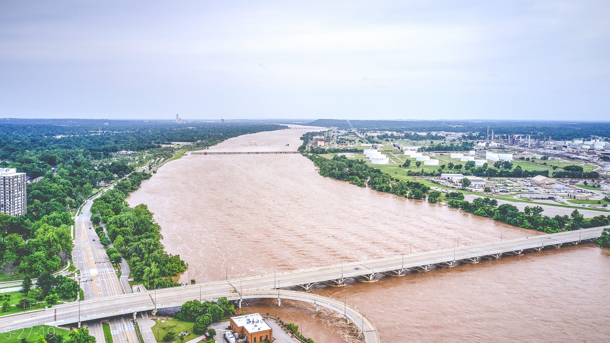
In the Arkansas River floodplain behind Levee C, a patchwork of unincorporated industrial zones loom among the neighborhoods of West Tulsa.
Two contaminated HF Sinclair refineries, a power plant and other industry sit feet from Eugene Field Elementary, Oklahoma State University medical school, about 260 homes, and multiple large apartment complexes.
More than a quarter of the residential area is occupied by River West: a new, $187.5 million “mixed-income workforce housing development” built by the City of Tulsa and Tulsa Housing Authority.
“It’s a big, complicated, already contaminated, future Superfund site.”
The EPA requires facilities with large amounts of certain hazardous substances with the potential to escape the property to submit a Risk Management Plan every five years.
Among other details, these reports disclose the name and quantity of each regulated hazard, the potential effects of a chemical accident, and the estimated reach of worst-case and alternative scenarios, called offsite consequences.
Risk Management Plans are meant to keep communities safer from chemical accidents and inform first responders and the public.
However, a regulation sponsored by Sen. Jim Inhofe in 1999 impedes public access to offsite consequence data with a labyrinth of legal pitfalls and practical constraints.
The act “encourages” emergency response and planning offices to make paper copies available to the public, but the rules are so elaborate and restrictive that agencies often don’t.4
Members of the public face a confounding set of requirements to view the data: advance planning, read-only access in a U.S. Marshals Service office, and reliance on handwritten notes.5
Fred Storer, a chemical and environmental engineer with more than 55 years of experience, has gone through the process eight or more times and described it as inconvenient.6
“I suspect that I am maybe the only person who has ever done this in Tulsa,” Storer said. “It's kind of grueling to sit there and copy this crap down on paper while the U.S. Marshal is sitting there with, you know, more important things to do.”
Tulsa’s West O’ Main area (left) and HF Sinclair West refinery (right). Video courtesy of Fieldguide Media
Storer’s notes from accessing the data in 2018 showed more than 120 million pounds of regulated flammable mixtures at the HF Sinclair refineries (then known as HollyFrontier) behind Levee C. When these materials escape containment, they can explode or start fires.
Storer, a former executive at Phillips Petroleum Company, said the refineries also hold raw materials like crude oil, and petroleum products such as gasoline, jet fuel and diesel in “very large quantities.”
The eventual failure of Levee C could lead to a release of hazardous substances into the air or water.
“It’s a big, complicated, already contaminated, future Superfund site,” Storer said of the riverfront refineries. “It’s a mess. … It’s gonna make things nasty at the Gathering Place, and along Riverside Drive, and on the way downstream through Jenks and Bixby. So you have like an oil spill, if you will, running along with the water.”
Storer said chemical clouds have the potential to kill more people. His notes from viewing offsite consequence data in 2018 showed 960,000 pounds of fuming sulfuric acid, a highly corrosive industrial chemical, behind Levee C at Chemtrade Refinery Services.
Chemtrade estimated that a quarter-sized puncture in a large tank at the site would produce a 3.1 mile radius of airborne contamination. In Chemtrade’s worst-case scenario, the radius doubled.
Storer said an accident involving the 318-ton tank could “make a hell of a mess in the river” and produce a toxic chemical cloud. Airborne exposure to fuming sulfuric acid can burn tissues and cause blindness or death.
“The sulfuric acid tank is a big deal,” Storer said. “Breathing sulfuric acid is very bad for you. Somewhere between a very uncomfortable feeling and a fatality.”
Despite these hazards, the Corps cited “no life safety risk” and “relatively mild” economic loss in the event of Levee C failing or overtopping.

The Corps’ response to my questions about Levee C leaned heavily on relativity.
For instance, the agency noted that residents behind Levee B will experience more significant flooding than those behind Levee C during flows of 360,000 cubic feet per second (cfs), around which point Levees B and C begin to overtop.7
However, higher flows make the difference less meaningful. The Corps anticipates that 400,000 cfs would likely cause all three levees to fail, resulting in as much as 15 to 20 feet of water in the formerly leveed areas.
These scenarios reflect a fraction of the flooding that is reasonably possible on the Arkansas River. (Recall that Keystone Dam can release an estimated 989,000 cfs.)8
The Corps’ population count behind the levees also raised questions.
A representative of the Corps initially told me the population behind Levee C was about 3,000, or “approximately ⅓ of the estimated population behind Levee B.”
However, the Corps later acknowledged that the number might exceed 4,500.9 As of 2019, an estimated 522 people lived behind Levee A and 5,201 behind Levee B.
Would everyone behind the levees have adequate warning and be able to evacuate?
The city’s 2019 All Hazard Mitigation Plan noted that Tulsans rely on sirens for emergency notification, but “very few” know the meaning of different tones.
The plan identified a need for city-wide awareness of safety protocols for hazardous chemical releases as well as levee failure: a scenario with “no known warning time or triggers for evacuations.”
The Corps’ own projections suggest that more than a quarter of residents will remain at home after the first 8 hours of an emergency.
The agency anticipates a “low to very low mobilization rate” based on findings that older adults and people with low income, who live behind the levees in significant numbers, “take longer to receive and understand evacuation warnings” and tend to resist leaving.10
These factors could “dramatically” increase fatalities, according to the Corps.11
“Life safety risk estimates are very sensitive to the evacuation response. … For example, with changes in the mobilization rate, fatality estimates tripled.”
—Tulsa-West Tulsa Levee Feasibility Study Draft Report, p. 109
Why did the Corps claim that lives are not at risk behind Levee C?
In a phone interview May 11, 2022, I asked David Williams, chief hydrologist with the Corps’ Tulsa District, to explain.
“I don’t understand the finding of no life safety risk if you know that more than a quarter of the residents are not gonna evacuate after 8 hours,” I said.
Williams said evacuation estimates involve “subjectivity.”
“It’s not that there’s no potential for life loss behind Levee C,” Williams said. Rather, the estimated number of deaths behind Levee C is lower than behind Levee B.
How would the Corps know the risks without investigating the potential for toxic spills?
Williams said assessing the risk of hazardous releases due to flooding was “not part of our methodology.”
“We’re talking about life safety as a direct result of inundation due to floodwaters, and the timing required for that inundation, and the depths of floodwaters that will be experienced,” Williams said. “So we’re not estimating life safety based on chemical hazards. We’re talking about floods. So, that’s why.”
Williams said the same was true of the economic loss analysis.
Without accounting for potential exposure to toxic spills or other industrial hazards, the Corps estimated that up to 21 people will die if Levee C fails.
The agency acknowledged that the risk of toxic spills due to levee failure “would likely increase consequence estimates.”
What could go wrong?
Storer described a number of possible events that could produce a refining or chemical disaster during a flood.
“We don’t know what tank might float and break what pipes, and so forth,” Storer said. “Probably the truth is, the big leak will be a consequence of three improbable events.
“… Somebody didn’t receive proper training, there was an inspection that failed—on and on and on. You can go back and look at all of the large chemical disasters around the world, and they almost always are the consequence of more than one thing going wrong.”
When Hurricane Harvey inundated Houston in 2017, spills at refineries and related facilities unleashed more than 22,000 barrels of diesel, crude oil, gasoline and other pollutants into the environment.12
At least 365 tons of hazardous chemicals spilled across Texas, creating living nightmares for residents and environmental and public health impacts that will never be fully known.
Reporters from The Houston Chronicle and Associated Press noted that many of the toxic releases were “barely noticed at the time” amidst the “record-shattering deluge.”
Storer said Tulsans are in for a rude awakening.
“We’re going to be really disappointed when the big flood comes,” he said. “The Gathering Place will be an island.”
Watershed subscribers will receive a higher volume of articles than normal between now and Friday, Aug. 30.
The City of Tulsa plans to open the Zink Dam development to the public over Labor Day weekend, and there’s a lot to know that you won’t find anywhere else. This means about 12 more emails in a short period of time, plus a bonus post related to the Aug. 27 election.
After Labor Day, I’ll give you and myself a breather before we continue on to the next part of the series. In the meantime, please share your favorite articles widely and support our work if you can. Thank you.

If you’re new to Watershed, start at the beginning:
1—The Natural Law

In the hills above Tenkiller reservoir, shrouded in forest on a blustery April morning, Casey Camp-Horinek (Ponca) addressed a circle of visitors. Camp-Horinek stood in a black and red hoodie, red ribbon skirt and traditional beadwork. Beneath swaying Blackjacks and Post Oaks, she opened Convening of the Four Winds, the second in a series of intertribal…
Find details about Tulsa’s levees and other water control structures on p. 83 of the All Hazard Mitigation Plan.
This statement appears on p. 12 of the Public Involvement appendix for the Tulsa-West Tulsa Levee Feasibility Study.
Although the Corps excluded Levee C from planned repairs during the Tulsa-West Tulsa Levee Feasibility Study, federal funds from two other sources are being used to update the pump stations along all three levees in response to damage from Tulsa’s 2019 flood, according to Levee Commissioner Todd Kilpatrick.
Pump stations return seepage to the river and transport stormwater, which cannot reach the river when outfall gates are closed during high water events. For details about the planned repairs to the levee system, go back to “The Known Unknowns,” the second article in this series.
The Chemical Safety Information, Site Security and Fuels Regulatory Relief Act relies on the premise that the risk of terror attacks and other harms outweighs the benefits of unencumbered public access to information about hazardous materials.
“Covered persons” like government officials, emergency planners and first responders who release offsite consequence data in prohibited formats or deviate from the law’s other convoluted parameters can face thousands of dollars in civil fines and criminal penalties of up to $1 million per year.
Joe Kralicek, executive director of the Tulsa Area Emergency Management Agency—a staff of five—said local organizations typically lack the resources to follow the “very burdensome” protocols for keeping offsite consequence data.
“That’s ultimately why you’re not going to find these [records] at pretty much any local entity," Kralicek said in a 2022 phone interview. "It’s easier for the locals not to have it. Because then I have to make it available, and I have to follow a lot of regulations related to it, and nobody’s paying for that.”
In 2024, a new provision of the law entitled people who live, work or spend significant time within 6 miles of the fenceline of a regulated facility to request specific types of information relevant to the regulated hazards, but not quantities or offsite consequences.
Facilities must make the information available “in English or in at least any two other commonly spoken languages” of the affected population and fulfill requests within 45 days. Although the rule took effect May 10, 2024, facilities have until May 10, 2027 to comply.
For everyone else, a list of regulated hazards for each site governed by the Risk Management Program is searchable with EPA’s Public Data Tool. However, the tool’s search results also do not include quantities or offsite consequences.
Here’s how to access offsite consequence data:
1. Six to eight weeks before you intend to view the data, request an appointment by calling the Department of Justice Federal Reading Room Appointment Line: 888-442-9267. Members of the public may view offsite consequence data for up to 10 sites anywhere in the U.S. per month; as well as any sites within the jurisdiction of the local emergency planning committee where you live or work; and sites with offsite consequences extending into your local jurisdiction.
2. The Department of Justice will obtain the information from the EPA and send a paper copy to the U.S. Marshal in your area. Fred Storer, a chemical and environmental engineer who has gone through the process eight or more times, said this step has taken up to six weeks and could take longer, particularly if you’ve never requested the information before.
3. Upon receipt, the marshal will contact you to schedule a viewing appointment at the U.S. Marshals Service office in Tulsa or Muskogee (the area’s designated reading rooms for the data).
4. Bring government-issued identification, proof of your home or work address, and pen and paper to the appointment.
5. Write down or commit to memory any information you wish to take with you. You may not photograph, record, or electronically or mechanically reproduce any information in the documents or remove them from the reading room.
6. Unless you are a “covered person” as described on p. 3 of this document, you may publicly distribute your notes about offsite consequences however you like when you leave the reading room.
Storer co-founded the Arkansas River Rights Coalition in 2021 to raise awareness of offsite consequences and the risks of industry-adjacent river development projects including Gathering Place, the new Zink Dam and whitewater flume, and Williams Crossing pedestrian bridge.
At Arkansas River flows of 360,000 cubic feet per second (cfs), the Corps anticipates 2-4 feet of water in residential areas behind Levee C and up to 13 feet in “isolated, low-lying industrial areas” behind the levee.
The same flows could cause widespread and deep flooding up to 15 feet in areas behind Levees A and B.
In 2017, the Corps reported “high confidence” that a Probable Maximum Flood would overtop Keystone Dam by 3.5 to 12 feet if it occurs: a worst-case scenario for the dam and communities downstream.
For details on the status of Keystone Dam and maps of the inundation zone, go back to “Wall of Water,” the sixth article in this series.
The Corps estimated in 2017 that between 1 and 4,500 people were at risk of flooding behind Levee C. In a June 14, 2024 email, staff confirmed that this range was “considered more accurate” than the agency’s initial response, which cited 3,000.
However, the higher estimate does not account for the residential units being added to the area with River West, the city’s $187.5 million public housing project.
The development adds an additional 65 to 90 new units and replaces 370 former units at the site. I was unable to verify these numbers, as Tulsa Housing Authority has not responded to fact-checking inquiries since April 11, 2024.
In any case, full occupancy would add several hundred residents to the population behind Levee C.
The Corps attributes evacuation resistance among residents to “possible mistrust of public officials and fears that personal property would be stolen after they evacuate.”
However, research about the relationships between demographic factors and evacuation behavior has produced mixed results.
From the Tulsa-West Tulsa Levee Feasibility Study, Appendix D:
A breach or overtopping of the Levee A&B system could result in the release of hazardous materials from the Sand Springs Superfund site, or from one of the many industrial entities behind the levee system. …
A breach or overtopping of the Levee C System could result in the release of hazardous materials from the Holly Refinery, or from one of the many industrial entities behind the levee system.
Hazardous materials could enter the Arkansas River, a major waterway, and affect communities and habitats downstream.
The impacts on life safety, as well as costs related to cleanup due to hazardous material releases during flooding have not been quantified for this assessment.
A decade earlier, back-to-back hurricanes Katrina and Rita spilled 190,000 barrels.
Good (i.e. terrible) example of siloed thinking within defined scopes. Naturally the Corps' scope is just death due to the water in the flood, but not the downstream consequences. The point about warning times and response of residents is interesting. Consider what happened in Montpelier, VT in summer 2023 and massive flooding in a "climate change safe county". Nice work on this one.
And now the Chevron decision has been reversed, making it almost impossible to hold the feet of those responsible to the conflagration they will cause.